


The Remonumentation Program is funded 100 percent by the State of Michigan, Department of Licensing and Regulatory Affairs. The program began as a 20-year effort to survey the State of Michigan. However, the time has been extended to complete the program. In Macomb County, the Maintenance Plan began in January of 2023. The Maintenance Plan provides for all original public land survey corners or protracted public land survey corners included in the county plan, and associated geodetic coordinates, to be maintained by requiring the filing of a land corner recordation certificate (LCRC) as required by the corner recordation act.
The first and last survey of the State was commissioned in 1815 and took approximately 40 years to complete. Original markers were 4-foot-long wooden posts. Most of the original markers have been removed due to road construction and development. The wooden posts have also deteriorated over time. Nonetheless, some of the original monuments have been recovered by following in the footsteps of the original surveyors and careful excavation.
The contracted surveying firms have researched, monumented, and approved a total of 2,409 GLO section corners, private claim corners, and property-controlling corners in Macomb County through December 31, 2022. The surveyors have also established 93 Global Positioning System (GPS) monuments and placed State Plane Coordinate values on 1,680 corner monuments. The GPS monuments and State Plane Coordinate values placed on the corner monuments provide reference points for computerized mapping.
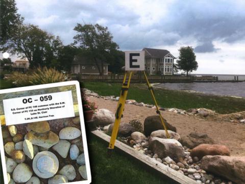
In the above photo, Roger Stecker, P.S. of Lehner Associates, Inc., set this monument (inset picture). OC-059 is a witness monument to the true Private Claim corner located more than 300 feet into Lake St. Clair.
According to Catherine DeDecker, Macomb County Surveyor Rep, “The Remonumentation and Maintenance Program will benefit land owners and surveyors for generations. This program will continue to maintain the public land survey monuments in their correct positions. Surveyors use these monuments to aid in property line determination, road rights-of-way alignment, and infrastructure improvements.”
Three Continuous Operating Reference System (CORS) stations have been installed as well. The stations are located in the Village of New Haven, the City of Warren, and Washington Township. The CORS stations are monitored by the Michigan Department of Transportation and have provided the most accurate GPS data in the world.
The 2023 Remonumentation Program will fund the research and monumentation of 45 corners including replacement of one Protracted Public Land Survey Corner and revisiting 44 Original Public Land Survey Corners. State Plane Coordinate values will be established on all 45 corners.
Please contact Catherine M. DeDecker, PS, Macomb County Surveyor Representative if you have any questions or comments. She may be reached at (586) 469-7916 or catherine.dedecker@macombgov.org.
- 2023 Entire Macomb County Progress Map
- 2023 Armada Twp-Armada - T5N R13E
- 2023 Bruce Twp-Romeo - T5N R12E
- 2023 Chesterfield Twp-New Baltimore - T3N R14E
- 2023 Clinton Twp-Mount Clemens-Harrison Twp - T2N R13E
- 2023 Erin-Lake Twp-Fraser-Roseville-Eastpointe-St Clair Shores - T1N R13E
- 2023 Harrison Twp-Mount Clemens - T2N R14E
- 2023 Lenox Twp-Richmond-New Haven - T4N R14E
- 2023 Macomb Twp - T3N R13E
- 2023 Ray Twp - T4N R13E
- 2023 Richmond Twp-Richmond-Memphis - T5N R14E
- 2023 Shelby Twp-Utica - T3N R12E
- 2023 Sterling Heights-Utica - T2N R12E
- 2023 Warren-Center Line-Eastpointe - T1N R12E
- 2023 Washington Twp-Romeo - T4N R12E
- CONTACT: Catherine M. DeDecker, P.S., Remonumentation Office, 120 North Main Street, Mount Clemens, MI 48043
- PHONE: (586) 469-7916
- EMAIL: catherine.dedecker@macombgov.org