


Hazardous weather
Terms:
- Blizzard warning: Snow and strong winds combine to produce blinding snow, deep drifts and life-threatening wind chill.
- Freezing rain: Rain that freezes when it hits the ground; creating a coating of ice on roads, walkways, trees and power lines.
- Sleet: Rain that turns to ice pellets before reaching the ground. Sleet also causes moisture on roads to freeze and become slippery.
- Snow squall: Intense periods of moderate to heavy snowfall, in limited duration, accompanied by gusty winds resulting in reduced visibilities and whiteout conditions.
- Wind chill: A measure of how cold people feel due to the combined effect of wind and cold temperatures.
- Winter storm watch: Be prepared. Severe winter conditions such as heavy snow, sleet or ice may affect your area, but where, when and how much is still uncertain.
- Winter storm warning: Take action! Heavy snow, sleet or ice is expected in your area.
Prepare:
- Make sure you have sufficient fuel for cars and generators.
- Weather-proof doors and windows to trap heat inside your home.
- Create an emergency supply kit
- Make sure animals are indoors well before cold weather hits.
- Insulate pipes with newspaper or plastic to keep them from freezing.
Be safe:
- Be sure to eat regularly and drink fluids.
- Watch for frostbite. Signs include loss of feeling or pale appearance of fingers, toes or face.
- Watch for cold related illnesses:
- Hypothermia: Signs include uncontrollable shivering, memory loss, drowsiness and exhaustion.
- If using a heater, make sure the area is well ventilated.
- If you must go outside, wear protective gear such as hats, mittens and gloves in addition to a warm coat. Always protect your lungs with a scarf.
- Change out of wet clothing immediately.
- Wear several layers of loose fitting clothes.
- Allow water to drip from your faucets to reduce the chance that they will freeze.
After:
- Check on elderly and children for any signs of illness due to the cold weather.
- Refill any supplies used from your preparedness kit.
More information/additional resources:
Terms:
- Air quality alert: Air pollution is high. Limit strenuous outdoor activity. Conditions to be on the alert for include wildfires, dust storms and smoke.
- Excessive heat watch: Be prepared. Extremely hot weather may develop across the region.
- Excessive heat warning: Take action. Extremely hot weather will develop across the region and will cause significant stress on people and animals unless precautionary measures are taken.
- Heat index: A measure of how hot it really feels when relative humidity is factored in with the actual air temperature.
- Heat wave: Prolonged period of excessive heat, often combined with humidity.
Prepare:
- Install air conditioning systems or know where the nearest air conditioned public place is located.
- Check your air conditioning system for proper insulation.
- Create an emergency supply kit
- Cover windows that receive sunlight.
- Keep a large supply of cold water where it is easily accessible.
- Weather-strip doors and sills to keep cool air in.
- Listen to local weather forecasts and remain aware of possible upcoming temperature changes.
Be safe:
- Watch for heat illnesses:
- Heat cramps: Muscular pains and spasms due to heavy exertion. The first signal that your body is having trouble with the heat.
- Heat exhaustion: Blood flow to the skin increases, which decreases blood flow to vital organs and creates a form of mild shock. The condition will worsen if it is not treated.
- Heat stroke: The body's temperature control system stops working and causes brain damage. Death may result in some instances.
- Stay indoors and limit sun exposure as much as possible.
- Spend the warmest part of the day in the air conditioning. If you do not have air conditioning, considering going to a public location or cooling center that does.
- Eat well-balanced, light and regular meals.
- Drink plenty of water. Avoid caffeinated and alcoholic beverages.
- Dress in loose-fitting, lightweight and light-colored clothing.
- Check on family and friends.
- Never leave children or pets in closed vehicles.
- Remember to give you pet extra water and limit their time outdoors.
- Take frequent breaks from any strenuous work or activity.
- Plan outdoor activities for the coolest times of the day.
- Always wear sunscreen. Sunburn limits your body's ability to dissipate heat.
After:
- Continue to drink water to restore proper hydration.
- Check on neighbors and family to make sure they are not suffering from a heat related illness.
More information/additional resources:
Terms:
- Flash flood warning: Take Action. A sudden violent flood that can take from minutes to hours to develop. Seek higher ground if you are in a flood-prone area. The flash flood is imminent or occurring. Never drive through flood waters!
- Flooding watch: Be prepared. Flooding may develop.
- Flood warning: Take action. Flooding is expected. Seek higher ground if you are in a flood-prone area. Never drive through flood waters!
Prepare:
- Make an itemized list of personal property well in advance of a flood occurrence.
- Assemble a disaster supplies kit containing: first aid kit, canned food and manual can opener, bottled water, extra clothing, rubber boots and gloves, NOAA Weather Alert Radio, battery operated radio, emergency cooking equipment, flashlight and batteries.
- If you live in a flood prone area, keep sandbags, plastic sheets and lumber on hand to protect property. Install check valves in building sewer traps.
- Know the elevation of your home.
- Check FEMA Flood Zone map to see if you are in a flood zone.
Be safe:
During:
- Avoid areas subject to sudden flooding.
- Never try to walk or drive your car across flowing water if you are unsure of the water's depth.
- Keep children away from playing in flooded streets, culverts and storm drains.
After:
- Refer to local health department and emergency management press releases for guidance as to boiling water requirements, proper cleaning techniques for personal property and open shelters in your community.
- Use flashlights, not lanterns or candles to examine your house. Flammables may be present and loose.
- Do not enter your home if you are unsure of the status of electricity in the home. Submerged outlets and live wires make for an extremely dangerous condition.
More information/additional resources:
For information on Flood Insurance offered here in Michigan through the National Flood Insurance Program, visit www.floodsmart.gov.
For more information regarding Flood threats and preparedness please see the links below.
Terms:
- Derecho: A widespread, long-lived wind storm that is associated with a band of rapidly moving showers or thunderstorms. A typical derecho consists of numerous microbursts, downbursts, and downburst clusters. By definition, if the wind damage swath extends more than 240 miles (about 400 kilometers) and includes wind gusts of at least 58 mph (93 km/h) or greater along most of its length, then the event may be classified as a derecho.
- Hail: Hail is a form of precipitation that occurs when updrafts in thunderstorms carry raindrops upward into extremely cold areas of the atmosphere where they freeze into ice. To be considered hail, the frozen precipitation pieces must have a diameter greater than 5mm.
- Severe thunderstorm watch: Be prepared! A watch is issued when severe thunderstorms are possible in and near the watch area. Winds 58 mph or higher and/or hail 1 inch or larger are possible in a severe thunderstorm.
- Severe thunderstorm warning: Take action! A warning is issued when severe thunderstorms is happening or is imminent in the warning area. Severe thunderstorms have wind 58 mph or higher and/or hail 1 inch or larger. Seek shelter
- Straight line winds: During strong thunderstorms, winds that are not associated with rotation. They can exceed 100mph. High winds can blow objects around and pose a significant threat to your safety.
Prepare:
- Remove dead or rotting trees and branches that could fall on your home with strong winds.
- Postpone outdoor activities until the storm has passed.
- Secure outdoor objects that could be blown around, such as garbage cans and patio furniture.
- Close all windows and blinds.
- Charge cell phones and other wireless communication devices.
- Sign up to receive text or e-mail alerts from your local media, weather provider or the National Weather Service.
- Plan a way to monitor local weather and news while in shelter.
- Identify the safest shelter location in your home; it should be on the lowest level, away from windows and doors.
- Prepare for a power outage.
- Create an emergency supply kit
- Purchase surge protectors.
Be Safe:
Signs:
- Rain
- Dark skies
- Lightning
- Increased wind speed
During:
- Pay attention to alerts and warnings.
- Do not use corded devices, such as house phone or anything that plugs into a wall outlet.
- Do not complete activities that use water or plumbing, such as laundry and showering.
- Stay away from windows and doors.
- If you are outdoors with no place to shelter, seek low level ground that is away from trees and metal objects.
- If you are traveling by car, pull over and remain in your vehicle until the storm passes.
- If you are boating or swimming, go to land and seek shelter immediately.
Lightning safety
According to the National Lightning Safety Council, from 2006 to 2018, 396 people were struck and killed by lightning in the United States. More than 70% of the lightning fatalities occurred in June, July or August.
If someone is struck by lightning:
- Call 9-1-1 immediately
- Check for breathing – if breathing has stopped, begin mouth-to-mouth resuscitation.
- Check for a heartbeat – if the heart has stopped, begin CPR.
- Check for other injuries, such as broken bones or loss of hearing and eyesight.
Note: It is okay to give first aid without fear of being hurt; the victim will not carry and electrical charge.
After:
- Wait 30 minutes before you go outdoors, remain cautious and remember that lightning can strike 10 miles away from a storm.
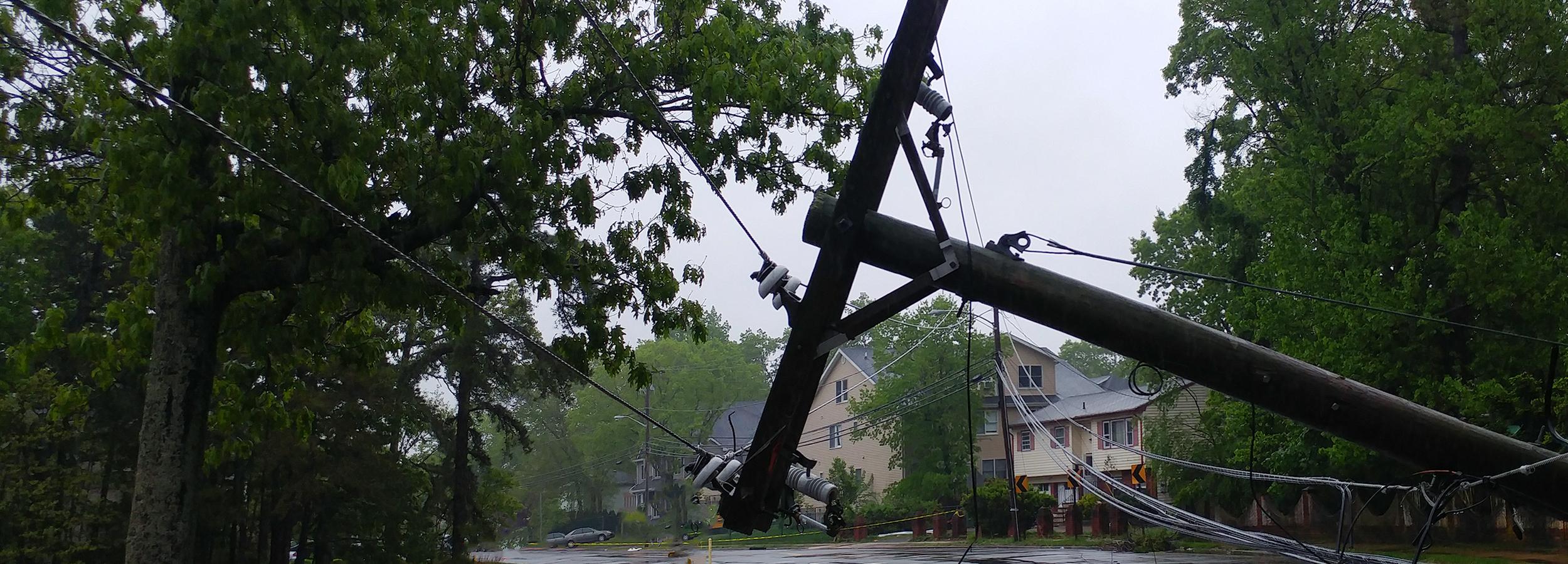
- Stay away from downed power lines.
- Monitor weather for other severe storms or any potential flash flooding.
- Check on elderly and children who may need help.
More information/additional resources:
On average Michigan has 15 tornadoes per year. Tornadoes are known for developing rapidly, with little advance warning.
Terms:
- Tornado watch: Tornado possible. Be prepared. Weather conditions favor thunderstorms capable of producing tornadoes.
- Tornado warning: Take action! A tornado has been sighted or indicated by weather radar. There is imminent danger to life and property. Take cover.
- High wind watch: Be prepared. Sustained, strong winds are possible. Secure loose outdoor items.
- High wind warning: Take action! Sustained, strong winds with even stronger gusts are happening. Seek shelter.
Prepare:
- Identify the safest location in the lowest level of your home.
- Talk to your family about how you will communicate in the event that you are not at home when a tornado hits.
- Plan a way to monitor local weather and news while in shelter.
- Sign up to receive text or email alerts from your local media, weather provider or the National Weather Service.
- Charge cell phones.
- Move lawn furniture and outdoor objects-such as trashcans-into the garage.
- Identify the safest location to shelter and know the building's safety plans if you are at work or school.
- Prepare for a power outage.
- Knowing the signs of a tornado.
Be Safe:
Signs:
- Dark, green-tinted sky
- Large hail
- Large, dark, low-lying clouds
- Loud roar
- Severe storms
- Tornadoes usually occur between 3 p.m. and 9 p.m.
- Tornadoes usually occur in the late spring and early summer
During:
- Seek shelter in the lowest level of your home. See sheltering guidelines for severe wind and tornado events for more information.
- Stay away from objects that can easily be blown around.
- Seek additional shelter under sturdy objects such as tables, couches or stairwells
- If no basement is available, seek shelter in the most interior room of your house.
- Stay away from windows and doors.
- Listen to a local media channel or NOAA weather radio for updates.
- Protect your head from glass and sharp objects.
- If you are in a car and no shelter is available, pull over and let your surroundings determine your next action to either:
- Stay in the car with the seat belt on. Put your head down below the windows, and cover your head with your hands and a blanket if possible.
- If you can safely get noticeably lower than the level of the roadway, exit the car and lie in that area, covering your head with your hands.
- Do not try to out run a tornado in your vehicle.
- If you are boating, go to land and seek shelter immediately.
After:
- Inspect your property and motor vehicles for damage. Look for electrical problems and gas leaks.
- Avoid and report downed power lines.
- Check on your food supply.
- Wear sturdy shoes, long sleeves, and gloves when you clean up debris.
- Check and restock and supplies from your emergency preparedness kit that were used.
- If you suspect home damage, shut off electrical power, natural gas and propane tanks.
More information/additional resources:
Warning systems
Outdoor warning system
The Macomb County Office of Emergency Management & Communications in conjunction with the Macomb County Sheriff’s Office operates an outdoor warning system by way of outdoor warning sirens that are located throughout the County. Following is a list of the communities that participate in the County’s system. If your community is not on this list, please check with your local government office for more information on your community’s outdoor warning system.
Participating jurisdictions:
- Armada Township
- Bruce Township/Village of Romeo
- Chesterfield Township/New Baltimore
- Clinton Township
- Eastpointe
- Fraser
- Harrison Township
- Lenox Township
- Macomb Township
- Mount Clemens
- New Haven
- Ray Township
- Richmond
- Richmond Township
- St. Clair Shores
- Utica
- Washington Township
The outdoor warning sirens are meant to alert those people outdoors, if an immediate threat has entered your community. The Macomb County Sheriff’s Office Dispatch is responsible for the activation of the outdoor warning system. In most instances this system is used for severe weather conditions but remember that when a siren is activated to never assume that you know what the threat is. Always seek shelter immediately and if your electricity has not been impacted, refer to your local media, to ascertain the nature of the threat and receive instructions regarding your safety. A battery powered radio is recommended for every household or business in the event that electricity is not available.
The system may be activated for the following severe weather conditions:
- Tornado warning as issued by the National Weather Service for our area
- Severe thunderstorm warning accompanied by winds 70 mph or greater as issued by the National Weather Service for our area
- Tornado and/or funnel cloud sightings that have been verified by a reputable source
The system may also be activated for other incidents that require immediate alerting of our population to take certain protective actions. These events may include, but are not limited to a hazardous material spill that may impact the community and require either an evacuation or in-place sheltering.
The County does not activate our system for an “all clear” notification once the threat is no longer present.
The outdoor warning system is tested the first Saturday of each month at 1 p.m.
The 911 system in the County and in your community should only be utilized to report an actual emergency, not to notify the dispatch center that either the sirens have been activated or to question why the sirens are activated. There are other sources for this type of information which include your local radio and TV outlets and the National Weather Service App.
For additional information regarding severe weather, sheltering or other emergency preparedness information please refer to our Community Emergency Preparedness Workbook. You may also contact the office at 586-469-5270 or MCOEM@macombgov.org.
NOAA Weather Radio All Hazards (NWR) is a nationwide network of radio stations broadcasting continuous weather information directly from the nearest National Weather Service office. NWR broadcasts official weather service warnings, watches, forecasts, and other hazard information 24/7.
In conjunction with federal, state and local emergency managers and other public officials, NWR also broadcasts warning and post-event information for all types of hazards – including natural (such as earthquakes or tornadoes), environmental (such as chemical releases or oil spills) and public safety (such as AMBER alerts or 911 telephone outages).
Learn more about All Hazard NOAA Weather Radios.
For non-English speaking residents the 911 center is also equipped with calling an interpreter 24 hours a day 7 days a week with the aid of AT&T Language Line. This service provides interpreters for more than 140 languages.
Macomb County Sheriff’s Communication Center provides all emergency and non-emergency call taking and dispatching for: Armada, Bruce Township Clinton Township, Harrison Township, Lenox Township, Macomb Township, Mount Clemens, New Haven, Ray Township, Richmond, Richmond Lenox EMS, Sterling Heights and Washington Township.
Every dispatcher is fully trained and certified in emergency medical dispatch, emergency fire dispatch and emergency law enforcement dispatch. The Sheriff’s Communication Center in 2020 answered 315,554 calls and 244 text messages. It dispatched 292,452 calls for service.
The Sheriff’s Dispatch Center has the ability to receive 911 emergency requests though SMS (Short Messaging Services), also known as cellular phone text messages.
The Sheriff’s Dispatch Center can receive the SMS text messages from persons messaging anywhere in Macomb County and using Verizon, AT&T, T-Mobile or Sprint cell-phone service providers.
When a request for emergency services (via text message) is received, dispatchers in COMTEC will be able to see the latitude and longitude from the cell phone user. However, the technology does not pinpoint the exact location from where the message was sent. The cell phone number from which the message was sent will display in the dispatch center.
If the emergency exists in one of the communities that are incapable of receiving 911 text messages, the Sheriff’s Dispatchers will maintain the text message session and relay the information to the proper PSAP (Public Safety Answering Point) so that emergency services will be provided.
While COMTEC will have the ability to receive the text messages, it is still preferable that callers make the voice calls to the dispatch center so that the dispatchers answering the phone can garner additional information about the call and dispatch the proper resources.
Do not text and drive. When in doubt –call 911!
Most 911 calls are made from a cellular phone, with very little information provided to a dispatcher. With Smart 911, call takers and first responders will have additional information that can be used to facilitate the proper response to a location. An individuals can sign up, at no cost, at www.smart911.com, and include an address, vehicles, medical alerts, emergency contacts, access information and download photos of pets or family. Citizens can create their own safety profile and when 911 is called, your safety profile is automatically displayed to the 911 call taker.
Skywarn

Skywarn is a nationwide network of volunteer weather spotters who are trained by NOAA's National Weather Service (NWS) to identify and report significant or severe weather such as: severe thunderstorms, tornadoes, hail, heavy snow and flooding.
Macomb County Emergency Management has partnered with the NWS to bring Skywarn Spotter Training to Macomb County.